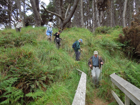
Thursday, August 16, 2012

AIRPORT, EARTHQUAKE TRAIL AND HOT SPOT


Photo credit: Gary Levenson-Palmer
Photo credit: Bob Rutemoeller
Meet at 10:15 at pullout for Gualala business directory north of bridge and at 10:30 at the Sea Ranch Business Center on Annapolis Rd. Turn right before the Fire Station on Verdant View. We can park at the end of the cul-de-sac by Sea Ranch Building Supply. Hang tags needed for non Sea Ranchers. Walk north on Timber Ridge Rd., then to the end of Sorcerer Wood. Take trail at post 102, pass 103 and 104. At post 105 take the trail to the left, at 106 a left again to backtrack past 104 to 103. Here take the trail on the left that leads to Ridge Rd. Walk the road down to Deep Woods Dr. on the left. Take this to the end and turn left on River Beach Road. Walk down until the road becomes one way. The start of the San Andreas Fault Interpretive Trail is on the left. After experiencing this guided trail, walk down to The Hot Spot for lunch and afterwards back to our cars via the Hot Spot Loop Trail, River Beach Road and Timber Ridge Rd. Walking sticks recommended.
Leader: Jane Sec

Thursday, August 9, 2012

SOUTH GERSTLE COVE BLUFF - "THE SLEEPING LION"

Photo credit: Bob Rutemoeller
Our Olympic obstacle course
Raven found by Mary Sue
Sleeping Lion
Glen Forbes Bench - A Gentle Spirit
Note: the trail starts at this mile marker
Photo credit: Nita Green


Carpool at 9:45 at pullout for Gualala business directory north of bridge and at The Sea Ranch Lodge at 10:00. Drive almost through Salt Point to MM 39.17 where there is a wide area to park on the right side of the road.  At 10:15 cross over to the gate on the east side of the road and follow a path north, parallel with the road. Cross the road at MM 39.4 continuing north until we pass the waterfall.  Follow the trail south to the South Gerstle Cove Picnic Area. From here we will follow the bluff as closely as possible until we reach the extreme southern boundary of Salt Point Park. We will return to our cars the same way we came. The rock formations and views from the bluff are outstanding. There are great photo opportunities for camera buffs. Just one warning: the paths are rough and eroded in places, and there are a few steep gulches to cross. The trail is not maintained, and disappears in some places. Hiking in Salt Point we are finding is quite an adventure these days. We will take a very leisurely pace and explore whatever attracts our attention. Be sure to bring walking sticks and be ready to lend a helping hand to your fellow hikers. There are several nice places to sit on the ground overlooking the ocean and have lunch, or we may wait until we return to the picnic area at South Gerstle. Our leader will point out a "sleeping lion" rock formation that is most visible on a sunny day at about 11:30. This hike is mostly level, but with obstacles. Dogs are not allowed on the Salt Point trails.
Leader: Gary Sprague

Thursday, August 2, 2012

SOUTH FORK OF THE GUALALA RIVER TO BUCKEYE CREEK aka A VERY BERRY HIKE

Photo credit: Nita Green
Double Gary + Double Ginger!
wild raspberries
wild thimbleberries
wild blackberries

Carpool at the pullout for Gualala business directory just north of the bridge at 10:15 and meet for the 2nd carpool at 10:30 at The Sea Ranch Business Center on Annapolis Rd. (turn right before you reach the Fire Station). We can park along the cul-de-sac by the building supply.  Sea Ranch members please bring along extra hang tags just in case. We will drive to Valley Crossing and park past the second bridge. We will be hiking on a mostly shady logging road walking north on the south fork of the Gualala River to Buckeye Creek where we plan to go down to the river for lunch and then return. This hike is mostly level, about five to six miles total. It's a little longer than our usual hikes but not hard walking.  Hiking on Gualala Redwoods land is usually very peaceful as we rarely encounter anyone and have a feeling of being in the wilderness. This is our once a year hike on their land.
Mary Sue Ittner

Thursday, July 26, 2012

NAVIGATORS REACH LOOP with POTLUCK

Photo credit: Jane Seck (note our pants match the color of the rocks perfectly)
Jane arranged for the Pelicans to fly over us. . .
Jane and Jim's lovely house. Note the deer in the background.
Note the starfish on the rock
It was a grey but not gloomy day
 Meet at 9:45 at pullout for Gualala business directory north of bridge and at 10:00 at end of Spar Close. (Turn on Annapolis Road from Highway One, left on Sea Ridge, left on Pilot's Reach, left on Spar Close.) Hang tags needed for non-Sea Ranchers. Walk to post 234 and take Pilot's Reach Trail to Pebble Beach. Take the bluff trail south to post 1, turn left through meadow and left on fire trail to Moonraker Road, continuing to bike path behind Moonraker Rec Center to Ramsgate Road. Cross Highway 1 at MM 51.85 and catch the Annapolis trail to Sea Ridge Road back to starting point, where we will have a potluck lunch. There is some elevation change; sticks are recommended.
Leader: Jane Seck

Thursday, July 19, 2012

FISK MILL BLUFFS

Photo credit: Nita Green
Photo credit: Bob Rutemoeller
Meet at 9:30 at pullout for Gualala business directory north of bridge to carpool and at The Sea Ranch Lodge parking lot at 9:45.  We will park at Salt Point State Park at large pull out on the right past MM 43.20. Starting time is about 10:00. We will take the trail through the grass and then turn south. We'll cross over on the rocks by the first gulch and find the trail that passes Sentinel Rock. From there we'll  take the bluff trail south and hike this unbelievably beautiful bluff  for about an hour. Before we get to Stump Beach we will turn around and hike back. Walking sticks are advisable and good boots since there isn't much maintenance these days on the trails and there are some uneven areas and potential crossings. We have a number of interesting choices for a lunch spot and the final spot will be determined by the leaders and those present. Dogs are not allowed on the Salt Point trails.
Leader: Leaders: Mary Sue Ittner & Bob Rutemoeller

Thursday, July 12, 2012

HUGEL RAVINE AND SEA RANCH HISTORY

Photo credit: Bob Rutemoeller
Photo credit: Nita Green
I missed this hike but rumor has it the hike was changed significantly.... but much enjoyed.

Meet at the Gualala Business Directory north of the bridge at 9:45 to carpool, or meet at 10:00 am at the Ohlson Ranch Center in the Sea Ranch (hang tags needed).  Parts of this hike are quite steep up and down (a total elevation gain of 600 feet) so walking sticks are advised. Walk first to the Knipp-Stengel Barn (ca. 1880), then cross the highway to pick up the trail at trail marker 254.  Travel a short way parallel to the highway, then turn uphill, turning right at trail markers 260 and 257. We will hike up the steep but very beautiful and wooded Hugel Ravine trail.  At the top, we will walk over to Rams Head Reach to view the knoll that from the mid-1800s was the heart of the German Rancho that later became the Del Mar Ranch and then Sea Ranch. Walk back up Seabird Road a short distance to Schooner Drive and pick up the White Fir Trail at trail marker 109.  This takes you to the ridge, where you turn right at trail marker 110. The trail becomes heavily wooded again after you turn left at trail marker 111 to head back down hill.  We will have beautiful downcoast views as we emerge from the forest to the meadows.  Travel downhill past trail marker 112, to 260, where we will retrace our steps the short distance back to the Ohlson Ranch Center to lunch at the picnic table or garden.
Leader: Linda Kennedy

Thursday, July 5, 2012

GUALALA POINT PARK #1


Meet at the Hidden Parking Lot at 10:00 (on westside entrance just left after pulling past fee post.) Or park across the street and cross Highway One if you do not have a pass.  Hike to the bluff, go north, and then back to the Visitors Center, walking occasionally on the road, but mostly on trails. After a brief stop on the benches to look at the view of the river, we will take the trail down to the river and under the highway to the campground. From there we will walk through the forest and down to the Gualala River for lunch. After lunch we will walk back to the cars via the road to the campground. We may see Lilium pardalinum in bloom. This is the 4 to 5 star (and bathroom) hike.
Leader: Mary Sue Ittner and Bob Rutemoeller