Thursday, December 29, 2016

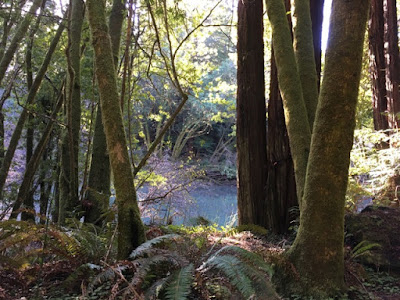
GUALALA ARTS TO GREEN IRON BRIDGE ROAD HIKE (potluck)

photo credit: Bob Rutemoeller


Meet at 10:00 in back part of Gualala Arts parking lot. Hike along the road down to the bridge and the end of the county road and back. We will walk through the local access to the river referred to as "Switchville"where lots of trash will be collected. There are some mild elevation changes and lovely glimpses of the Gualala River. Harmony & Sus will prepare something hot for us and the rest of us can bring something to go with it for lunch following at the Gualala Arts Center.
Leader: Harmony
mileage: 5.17

Thursday, December 22, 2016

ALDER CREEK ROAD AND MANCHESTER STATE PARK BEACH LOOP

photo credit: Bob Rutemoeller
photo credit: Gary Levenson-Palmer
photo credit: Mary Sue Ittner

Meet at 10:20 at pullout for Gualala business directory and at Anchor Bay (west side of Hwy 1) at 10:30. We will turn in at Alder Creek Beach Road (mm 22.48), then turn directly left and park parallel on the road that parallels Highway One. Hike starts around 11. Mary will lead us to a nice view point before we make our way to the beach. Hike was modified from original because the rivers were impassable due to rains.
Leader: Mary Heibel

Thursday, December 15, 2016

GUALALA POINT PARK BLUFF AND LOOP

CANCELLED DUE TO RAIN:

Start at Hidden Parking Lot at 10:00  (on westside entrance just left after pulling past fee post.)   There is a fee per car. (Or park across the street and cross Highway One if you do not have a pass.) Walk through the Serge Poles and then cross the road to the bench overlooking the Gualala River. Take the trail from there that leads to the Visitor Center and from there the northernmost trail to the bluff. Hike to Whale Watch Point for the view and then turn south and walk along the Bluff Trail past Salal Cove. Between post 64 and 63 turn left walking through the hedge row and on Fish Rock Road to Leeward. Turn left on Leeward and walk until you intersect the Salal Trail. Turn right following it back to the highway and the Hidden Parking Lot.  Lunch at the picnic tables at the end.
Leader: Linda Kennedy

Thursday, December 8, 2016

HENDY WOODS STATE PARK - canceled - due to rain

all photos by Bob Rutemoeller

Meet at 8:30 at pullout for Gualala business directory and at Anchor Bay (west side of Hwy 1) at 8:40. A bit of drizzle, but no heavy rain for the Gualala Point Park hike as an alternative to the Hendy Woods SP hike originally scheduled.
Ginger Thompson-Veys

Thursday, December 1, 2016

STENGEL BEACH ACCESS LOOP (new)

photo credit: Laura Bridge
photo credit: Steve Coffeysmith
photo credit: Laura Bridge

Carpool at pullout for Gualala business directory just north of bridge at 9:45 and park at the public access trail for Stengel Beach at 10:00. Take the access trail to the Bluff trail and follow it south to post 9. Turn left and take the Pebble Beach access, turning left on the bicycle path before you reach the parking area, continuing on Sculpture Point Drive, right on Navigators Reach, and left on bicycle path. Follow it and the trail to 14 b and c. Cross the highway and continue in the same direction taking 242 on the Firebreak trail to 243 on the Longmeadow trail and going northwest on it around the stables and crossing the highway again at Wild Iris. Depending on the weather lunch will be optional or at one of the beaches or the Ohlson Rec Center.
Leader: Theresa Yuen

Thursday, November 17, 2016

SCENIC VIEWS AND COOKS BEACH


all photos above by Bob Rutemoeller
Carpool at the pullout for Gualala business directory just north of bridge at 10:15 or drive directly to the parking area west of Big Gulch Road (north of Gualala after mm 2.16 where Cal Trans sometimes dumps material) where you will meet the leader. We will start walking at 10:30. We will walk south along the Old State Highway and the route of the old railroad. Turning around close to where the Old Milano used to be, we will retrace our steps and walk along Highway 1 north.  This is a scenic corridor with nice views. We will do a short loop east of the Highway on Glennen for more views of ocean and houses before walking  to Cooks Beach. Cooks Beach is a RCLC project providing public access to a sheltered beach. We will descend to the beach for lunch and then return along Highway One to the cars.
Leaders: Mary Sue Ittner and Bob Rutemoeller

Thursday, November 10, 2016

POINT ARENA PUBLIC LANDS LOOP

All photos by Bob Rutemoeller & Mary Sue Ittner
Meet at 9:20 at pullout for Gualala business directory and at 9:30 at Anchor Bay (west side of Hwy 1) to carpool and start at Point Arena City Hall at 10:00.  After entering the public lands, take the trail on your right. Walk north until you reach a road that will lead you to the bluff and spectacular ocean views. Follow the bluff for a while to appreciate the spectacular middle section and then turn around and walk south along the bluff and return with views of Arena Cove.  A suitable lunch spot will be found with a good view before returning to the cars. This is mostly coastal grassland so there isn't much elevation change, but the ground is uneven and there are gopher holes so good hiking shoes are helpful.
Leaders: John & Lynn Walton

Thursday, November 3, 2016

CORMORANT-WALK-ON BEACH LOOP


10:00 at Steve and Bonnie Coffeysmith’s house, 339 Bluff Reach, corner of Bluff Reach and Cormorant Close. Walk to marker 30A and follow the hedgerow to marker 30D. Turn left and follow the trail straight through 31C to 33B. Turn right on Pacific Reach and Whalebone, toward Rt. 1. Turn left at marker 34A, left at 35D, and right at 35C. Continue hiking through the meadows to marker 42C, then turn left and walk to 42, overlooking Walk-on Beach. Turn left and follow the Bluff Trail, passing the TSRA Marine Preserve and Dune Drift Beach at marker 38. Hike to marker 37 and follow the sand trail to the cypress hedgerow, turn right and go to Tidepool Beach to look for harbor seals. Continue on the trail, passing Shell Beach and stopping to check out the cormorant nesting area before returning to the Coffeysmith’s to enjoy your bag lunch.
Leader: Steve Coffeysmith